Friday, September 30, 2011

Wall parers, Video, Photos Tahiti Peninsula

French Polynesia, Scattered Clouds. Underwater world at Laguna Riu, View of the Plateau Taravao, चमत्कार

  Tahiti is the largest of the 118 islands and atolls that make up French Polynesia. 467km  area consists of mountain peaks with heights up to 2.241m forming a crown in the scattered clouds. Deep valleys covered by tropical forest  with waterfalls that spill into cool rivers flowing through fields of flowers.
.

             Around Tahiti-Nui (big Tahiti) of 114 km road winds between the sea and mountains, and Tahiti Peninsula-I (the small Tahiti) the road continues another 20 km on both coasts. Interior road passing near dairy farms and citrus groves, for panoramic view of the Plateau Taravao - isthmus connecting two islands. Although the island of Tahiti is very attractive, large population here makes extended stay is not pleasant. Other nearby islands Moorea, Bora Bora, Huahine is an oasis of beauty and romance, being more suitable for holiday and honeymoon than Tahiti.
Tahiti - Tahiti Nui
Tahiti - Tahiti beaches
   Tahiti and trips but have enough opportunities to be a pleasant location for a few days. You can visit the Harrison Smith Botanical Gardens, you can learn something about the history of the islands at the Museum of Tahiti and Islands, you can see the underwater world at Lagunariu and the Gauguin Museum you can see the artist's paintings. The museum is open every day from 9 to 17. Activities include sailing at the spectacular American land, island tours, helicopter tours, horse riding, tennis, diving, fishing, water skiing and day trips to the atoll, Tetiaroa, which belonged to Marlon Brando.
Tahiti - Panoramic landscape
Tahiti - Moorea
Tahiti - Bora Bora Island

Thursday, September 29, 2011

Great Barrier Reef ; Top wonders of the world

ரீப் உயர் தடை, The Great Barrier Reef

 
ரீப் உயர் தடை, The Great Barrier Reef is the largest coral reef world. It is situated  in Australia. It covers 2 600 km from Bundaberg to the tip of Cape York. Covering an area of 350 000 km ², it can be seen from space. By comparison, Germany has an area of 357 000 km ². The Great Barrier Reef has more than 2 000 islands and reefs around 3 000 of all kinds. It can be seen near the coast, but the most spectacular are some 50 km offshore. It is listed as World Heritage by UNESCO
Great Barrier Reef - General view .
   The reef is considered the largest living structure on Earth. It is sometimes called the largest living animal in the world. In reality, it consists of many corals. Because of its vast biodiversity, warm clear waters and its accessibility, the reef is a popular destination for scuba divers. For Australians, thousands of islands, islets and atolls make up the Great Barrier Reef is the 8th wonder of the world. 350 species of coral sizes, shapes and colors to home, in a bright blue water, over 1 500 species of fish and shellfish
Great Barrier Reef - Diversity of life
   Many cities along  coast offer daily departures by boat to the reef. The city of Cairns, North , is the starting point for most people to get to some of them. Several  islands have been transformed into a holiday. Much of the reef is now protected by the Great Barrier Reef Marine Park. It is in danger because of marine pollution, global warming and fisheries. The first European explorer to have discovered the great barrier was Captain James Cook during his voyage of 1768. He found the reef when the steamer over June 11, 1770.
Great Barrier Reef - Heart-shaped reef

Tuesday, September 27, 2011

இத்தாலி, Pictures of the World : Italy, Beautiful Photos

The most romantic destinations in Italy, இத்தாலி

Positano

is a town on the Amalfi coast of Campania, Italy. Most of the city is an enclave that descend toward the shore. From here you can take the ferry to Paestum, Ischia and Capri, during the summer. Are two beaches in Positano. Fornillo - a small and secluded beach, accessible by stairs from the grotto from above or from Spiaggiata Grande. Fornillo has a more relaxed atmosphere, with four bars on the beach and away from the ferry.
Positano - Night view of Positano
Positano - General view

Venice in Italy

For most people, Venice is synonymous with romance. Of course there are detractors, but most people love this city, imagining it as a symbol of love, inspired by stories of love sheltered by the walls of buildings shriveled.    But nobody can deny there is something with this place, something that continues to fascinate generations of tourists, lured by fame and the history of the city that floats on water.
Venice in Italy - Gondolas

Capri Island

The first to discover the magic of this island of Italy was Caesar Augustus who, in the year 29 BC, the island of Ischia Naples offered in exchange for small paradise with an area of only 10 square kilometers. Capri has been the residence of Emperor Tiberius, the Renaissance artist refuge, resting place of French kings, and, later, political personalities holiday destination.
Capri Island - Panoramic setting

Saturday, September 24, 2011

The Wonder, Pictures of Singapore, Changi Airport : Photo

Singapore Changi Airport, 世界上最美丽的机场,

Singapore Changi Airport

  Rises up as a veritable airport hub based in the Southeast Asia region and this  is the most important  airport in Singapore. The airport includes  about 4,340 flights every week, operated by 80 airlines to over 116 cities in 59 countries, serving  over 36,701,556 passengers annually. Singapore Changi Airport is regarded as the 19th busiest airport in the world and the 5th busiest in Asia for the passenger traffec.
Changi Airport in Singapore - Fantastic beauty
   Having received  limited land resources in Singapore, the airport was created for both current and future need, representing  the country's main airport. The airport was designed to feature the possibility to be doubled  in size using reclaimed land, with more space perfect for two more runways and at least two new passenger terminal buildings. Changi International Airport, carefully raised at the eastern side of Singapore, it was officially inaugurated on  the 29th  December 1981. The beautiful site was constructed almost entirely on reclaimed land nearby the  initial airbase was located. When opened for the first time, the airport was the first at everything,  for example the world's largest airport and designed with  the world's largest column-free hanger at 20,000 square  meters
Changi Airport in Singapore - Great design
.Changi Airport in Singapore - Interior view

Friday, September 23, 2011

Vienna Wonders ; St Stephen's Cathedral


Why the St Stephen's Cathedral in Vienna is special

Its interior, roof, and soaring tower are unique and stunning in design and architecture.


Top 3
St Stephen's Cathedral
attractions


Interior overall

Don't miss the Stone Pulpit (exquisitely carved), the Altars (especially the High and the Wiener Neustadt altars), and the many other precious artworks.

South Tower

It is one of Vienna's most beloved icons. It rises as high as a modern 40-story building, an amazing engineering feat for a virtual-stand-alone 15th-century steeple.

Roof

St Stephen's Cathedral's steep-sloped roof is blanketed with colorful multi-hued glazed tiles set in striking geometric patterns.

Other major St Stephen's Cathedral attractions include

North Tower

Though half as high as the South Tower, it, too, offers a stellar panoramic view of Vienna and beyond. Unlike the latter, it has an elevator.

Catacombs

View royal tombs and piles of commoner bones.

Heathen Towers

They are 900 years old.

Thursday, September 22, 2011

உலகில் சுத்தமான இடங்கள், Pictures of Kamchatka, World Heritage Site

Wonders Images of Kamchatka, icons, photos, figures, visions,
     The peninsula was closed to foreigners during the Soviet Union. Now, Kamchatka is opened to all who want to see the black ocean beaches, volcanoes enveloped in smoke, the hot water geysers, bears and snowy mountains paths. Kamchatka’s area is of 473,300 square kilometers. The taiga and tundra wilderness is of endless natural beauty  and includes some islands. The Okhotsk Sea coasts are washed by the Bering Sea and the Pacific Ocean. 28 of the 29 active volcanoes are located in the east and west of the peninsula. The volcanic region of the peninsula was declared a UNESCO World Heritage Site in 1966. Kamchatka boasts hot springs scattered almost everywhere, the valley of geysers where are over 20 big geysers, a rich flora and fauna, bears, wolves, polar foxes, eagles and many species of fish that inhabit the rivers.
Kamchatka - Coast of the Pacific
Kamchatka - Natural beauty
   Do you have time and money and you want to get acquainted with one of the cleanest places on the planet? Do you want to get acknowledged with some other cultures, experience a lot of adventures and at the same time equally relax? Then, travel to one of the cleanest places on the Earth. This trip is suitable for lovers of beautiful landscapes and cultural values and anyone would be happy to spend little more money on luxury accommodation and excellent food.   Embark on an unforgettable beauty - hidden waterfalls, majestic cliffs, magnificent coves and bays. Many places on this planet have their special charm and amaze with breathtaking scenery. If you're tired of noisy places and pollution and want to recharge your batteries with positive energies it's worth trying something totally different.
Kamchatka - Foggy view

The Beautiful Fiordland National Park, New Zealand, Wallpapers

Fiordland National Park - The Cleanest Places in the World

        Located at the southern tip of New Zealand's west coast, the park encompasses beautiful landscapes and wild surprises. The mountains are covered with tropical forests. Because it is the largest park in New Zealand, the park is an attraction for those who practice hunting and fishing, or for those who want to collect the precious stones that are hidden in this beautiful area. The region brings clean air currents from Antarctica, which makes the park to be one of the cleanest places on the planet. Fiordland National Park, the largest in New Zealand has an area over 12,500 square kilometers. The country of fjords basically constitutes of mountains. They are a continuation of the Southern Alps and their height reaches 3000 meters. In the past, this area was covered with a huge glacier, which is melting, cut up the slopes of the mountain range, deep gorges, forming many picturesque bays, fjords, and long, narrow lakes
Fiordland  National Park - Heavenly place.
Fiordland  National Park - Amazing attraction
Fiordland  National Park - Fascinating place
   New Zealand Mother Nature has generously endowed beauty. And the best and most beautiful landscapes of New Zealand are concentrated here - in the Land of Fjords. Everyone who gets in these parts for the first time is amazed. It seems that even today any man's foot stepped on this earth. A feature of the coast of Fiordland is that the rocks forming the coves go into the water sharply and it seems that the place to find the landing is simply not possible. Another feature of these places is surprisingly the close proximity of the forest with glaciers. Another place where the southern beech, laurel, myrtle is so closely side by side with a snow-crystal layer of ice, perhaps cannot be found on the Earth

Wednesday, September 21, 2011

The wonders, The Great Barrier Reef, Australia, Video

Why the Great Barrier Reef is special


Grand in many respects
Size
The Great Barrier Reef stretches 2300 kilometers (1400 miles) in the Coral Sea along Australia's northeastern coast.
Formations
There are 3,000 coral reefs plus many islets, atolls and coral cays.
Wildlife
The Great Barrier Reef supports 10,000 species including 1500 types of fishes and 200 kinds of birds. Other inhabitants include whales, dolphins and sea turtles.
Underwater spectacle
The sheer beauty of its fish and coral waterscapes draws two million tourists annually who come to see the underwater spectacle via diving, snorkeling and glass-bottom boating.


Great Barrier Reef Ecological Threats


Vulnerable
This complex and delicate eco-system can be easily damaged or even destroyed.
Visitor impact
Great Barrier Reef conservationists fear that the large influx of visitors and their collaterel effect on pollution are damaging the very natural wonder that people come to celebrate.
Overfishing and pollutants
Culprits include boats, farms, ranches and industry.
An even greater threat
Many scientists see an even greater threat: Global Warming. It's unlikely that the Great Barrier Reef of Australia would survive if the water temperature rose by 5% or so over its current average.

Saturday, September 17, 2011

Iguazu Falls, Iguassu Falls, or Iguaçu Falls, Power of Wonder;videos, Wallpapers

      Sri Chinmoy established a plaque dedicating the site as "A Sri Chinmoy Peace Falls". This video offers you the power, majesty and beauty of the Iguazu Falls which following a recent news item nearly dried out because of a long drought period in 2009. Soundtrack by Parichayaka Hammerl


 Tourism


Panorama of the falls
There are two international airports close to Iguassu Falls: the Brazilian Foz do Iguaçu International Airport (IGU) and the Argentine Cataratas del Iguazú International Airport (IGR). Argentina airport are several kilometers from the Iguassu Falls and from the neighboring city Puerto Iguazu. Brazilian airport is on Foz do Iguaçu, Brazil. LAN Airlines and Aerolíneas Argentinas have direct flights from Buenos Aires and several Brazilian airlines as TAM Airlines, GOL, Azul, WebJet offer service from the main Brazilian citie


Why Iguazu Falls is special

Iguazu Falls stretches along a 3 kilometer (nearly 2 mile) long rim that is shared by Argentina and Brazil. I was flabbergasted watching it thunderously plunge the height of a 24-story building into the Iguazu gorge below.

Which is best, the
Argentine or Brazilian
side of Iguazu Falls?


Both have their pluses
The Argentine side has the best and most varied up-close views of Iguazu Falls while the Brazilian side has the spectacular panoramic view. My best advice: See both.

Best time
for sightseeing

Defining "best" depends on your priority. There are significant trade-offs:

If you want to
experience Iguazu Falls
at its full might
Go during the rainy season (normally the rain is heaviest from around December to February). However, you might encounter cold and dreary days as well as sightseeing trails that are occasionally closed due to rain damage.

If you want warm,
blue-sky weather
Go during the dry season (typically from April to July). Unfortunately, Iguazu Falls noticeably dwindles in strength. If you are very unlucky, Iguazu Falls may be completely dry (which occurs for a week or more every several decades or so).

More
Iquazu Falls
tips & insights


How Iguazu Falls
compares with
other great falls
Iguazu Falls (which ranks 9 among the world's top wonders) is rivaled in mightiness only by Victoria Falls in Africa (ranks 15). The world's other two gold medal-winning falls are Angel Falls (ranks 79) and Niagara Falls (88).

Iguazu Falls'
top attraction
Of all the many tall cascades that collectively make up Iguazu Falls, the semi-circular Devil's Throat is by far the most awesome. It is the world's mightiest single water fall (in terms of water-flow volume) - and its incessant roar is deafening, to the point of being terrifying.

Recommended
length of stay
Most visitors to Iguazu Falls fly in from either Rio de Janeiro in Brazil or Buenos Aires in Argentina. Some do it as a day trip. I strongly suggest staying at least two days - one to explore the Argentine side, the other, the Brazilian side.
800px-Garganta_del_Diablo_or_Devil_Throat_Iguazu_Falls_Argentina_Luca_Galuzzi_2005

Thursday, September 15, 2011

Natural Wonders, Sedona Arizona, Beautiful Red Rocks; Spectacular Video,

Sedona Arizona - Spectacular Photos and Views of the Beautiful Red Rocks

           The breathtaking beauty of Sedona, Arizona captures those who are lucky enough to experience the magnificent, natural red rock sandstone formations surrounded by pristine National Forest. Sedona has an intrinsic mystique that radiates from the landscape and many become caught-up in a sense of wonder and awe as they gaze upon it.

Sedona's natural beauty seems to go beyond what pleases the eye. There is an extraordinary energy which permeates the very soul as one experiences the red rock formations which have been sculpted by the forces of nature over eons and eons. Sedona is purportedly home to several vortices–swirling pools of electromagnetic energy that radiate from the earth. The more popular vortexes are Bell Rock, Cathedral Rock, Boynton Canyon, and Airport Hill. These sites in Sedona are said to be similar to various other power spots around the world.


Why Sedona Red Rock Country is special

Majestic reddish sandstone formations around the small, artsy town of Sedona in northern Arizona in America create natural scenes of awesome beauty.

Sedona Red Rock Country tips & insights


When to come
The area can sometimes be very hot in mid summer. The ideal times to come are April to mid-June and mid-September to mid-November (when nature's autumn foliage display of red, orange and yellow colors occurs).

Best time for photographing
Take most of your photos in the late afternoon when the sun's low-angled rays intensify the red sandstone hues. Morning light is fine, too, but many of the top photogenic sites are better positioned for late-day shots.

Creation
The formations were carved over the ages by the erosive effects of wind, water and ice. They are varied: buttes, pinnacles, canyons and mesas.

Why the rocks are red toned
The sandstone acquired that hue because its iron component had rusted (oxidized).

Movie location
For 75 years the Sedona area has been serving as a backdrop for Hollywood movies.


The wonders, Niagara Falls in USA, Videos, Photos, Trip Advise

Images of Niagara Falls in USA, icons, photos, figures, visions, appearances, illustrations, snapshots, captures, canvas and pictures of Niagara Falls in USA - Top wonders of the world

Niagara Falls is one of the most spectacular natural miracles of the North American continent. Niagara Falls is a waterfall assembly located on the border between northern state of New York and Ontario in Canada. Lake Erie is connected with Lake Ontario via the Niagara River with a difference of 58 m, the water being separated into two arms of the Island "Goat Island" (Goats Island). On the North American waterfall has a width of 363 m water waterfall fall from 21 meters high, while the Canadian with a 792 m wide (horseshoe shaped), height is 51 m. Water loss is the Niagara and no more than the highest waterfall but it is perhaps the most famous and among the most impressive. Cascade flow is averaged over 4000 cubic meters per second (twice the flow of the Rhine). Tourists come here from the 19th century and has become the honeymoon capital. The whole area of tourism flourished, being studded with museums and amusement parks.


Niagara Falls in USA - Excellent views

Why Niagara Falls is special

It is one of the mightiest falls on earth. Although Niagara Falls is smaller and less breathtaking than Iguazu Falls in South America and Victoria Falls in Africa, it is awe-inspiring in its own right.
Seasons
The time of the year
makes a big difference
in what you'll experience
Summer - Positive pointsSummer is best in terms of water fall strength. The greater the volume, the more spectacular the viewing experience.
Summer - Negative pointsUnfortunately, summer is the season when the lion's share of the 15 million annual visitors come. Crowds can be overwhelming and line waits unbearable.
Winter is the leastdesirable time to visit
Winter can be bitterly cold, a major factor considering that watching the falls is primarily an outdoor standing activity. Moreover, in deep winter, layers of ice can hide the falling water.CompromisesThe two best compromise times are early May and late September.
Best sightseeing
times of day
During the peak
summer period
Avoid long lines by scheduling your visits to the popular attractions in the morning (before 10:30 a.m.) or late afternoon (after 4:00 p.m.).  And, if possible, avoid weekends.
Niagara Falls in USA - Aerial view

Niagara Falls in USA - Breathtaking views


Sunday, September 11, 2011

The Wonders Taj Mahal 3D Video, Wallpapers, Histry

Taj Mahal Is Truly a Wonder of the World,wallpapers,history

Why the Taj Mahal Is Truly a Wonder of the World


taj 1
Agra, once the capital of the Mughal Empire during the 16th and early 18th centuries, is one and a half hours by express train from New Delhi. Tourists from all over the world visit Agra not to see the ruins of the red sandstone fortress built by the Mughal emperors but to make a pilgrimage to Taj Mahal, India’s most famous architectural wonder, in a land where magnificent temples and edificies abound to remind visitors about the rich civilization of a country that is slowly but surely lifting itself into an industrialized society.
2047-taj-mahal-wallpapers
The postcard picture of Taj Mahal does not adequately convey the legend, the poetry and the romance that shroud what Rabindranath Tagore calls "a teardrop on the cheek of time". Taj Mahal means "Crown Palace" and is in fact the most well preserved and architecturally beautiful tomb in the world. It is best described by the English poet, Sir Edwin Arnold, as "Not a piece of architecture, as other buildings are, but the proud passions of an emperor’s love wrought in living stones." It is a celebration of woman built in marble and that’s the way to appreciate it.

Saturday, September 10, 2011

Top 10 Mysterious Geological Wonders in the World, Beautiful Photos

The Wave between Arizona and Utah,  USA

Click here to enlarge image
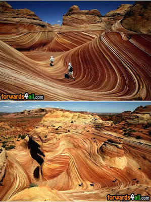
A red-rock stunner on the border of Arizona and Utah, The Wave is made of 190-million-year-old sand dunes that have turned to rock. This little-known formation is accessible only on foot via a three-mile hike and highly regulated.

Antelope Canyon, Arizona,  USA

Click here to enlarge image
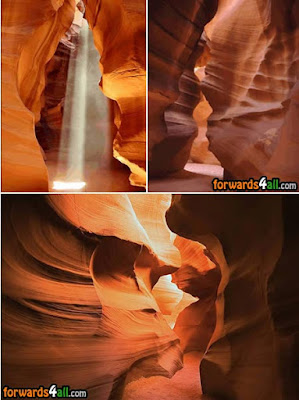
The most visited and photographed slot canyon in the American Southwast, the Antelope Canyon is located on Navajo land near Page, Arizona. It includes two separate, photogenic slot canyon sections, referred to individually as Upper Antelope Canyon --or “The Crack”-- and Lower Antelope Canyon --or “The Corkscrew.”
The Navajo name for Upper Antelope Canyon is Tse' bighanilini, which means "the place where water runs through rocks." Lower Antelope Canyon is Hasdestwazi, or "spiral rock arches." Both are located within the LeChee Chapter of the Navajo Nation.

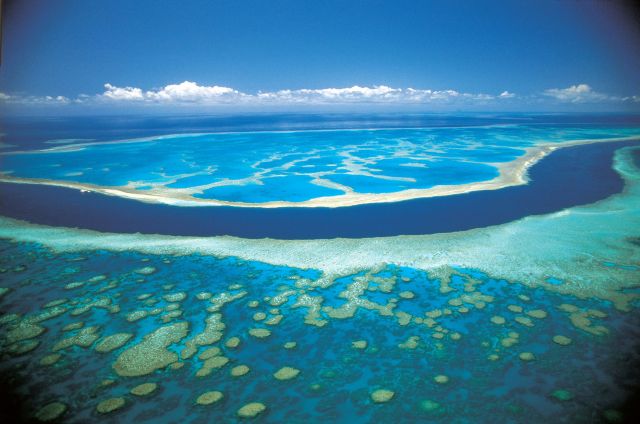
Great Blue Hole,  Belize

Click here to enlarge image
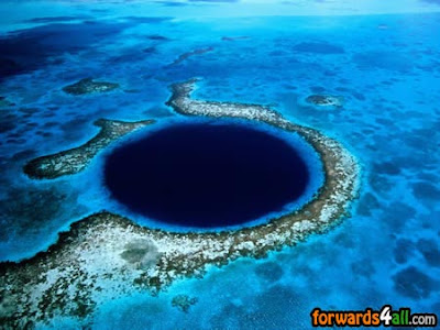
Part of the Lighthouse Reef System, The Great Blue Hole lies approximately 60 miles off the mainland out of Belize City. A large, almost perfectly circular hole approximately one quarter of a mile (0.4 km) across, it’s one of the most astounding dive sites to be found anywhere on earth. Inside this hole, the water is 480 feet (145 m) deep and it is the depth of water which gives the deep blue color that causes such structures throughout the world to be known as "blue holes."

Crystal Cave of the Giants (Mexico)

Click here to enlarge image
Found deep inside a mine in southern Chihuahua Mexico, these crystals were formed in a natural cave totally enclosed in bedrock. A geode full of spectacular crystals as tall as pine trees, and in some cases greater in circumference, they are a translucent gold and silver in color and come in many incredible forms and shapes. The Crystal Cave of the Giants was discovered within the same limestone body that hosts the silver-zinc-lead ore bodies exploited by the mine and it was probably dissolved by the same hydrothermal fluids that deposited the metals with the gypsum being crystallized during the waning stages of mineralization.

Eye of the Sahara,  Mauritania

Click here to enlarge image
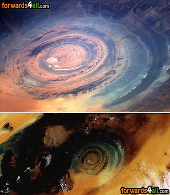
This spectacular landform in Mauritania in the southwestarn part of the Sahara desert is so huge with a diameter of 30 miles that it is visible from space. Called Richat Structure --or the Eye of the Sahara-- the The formation was originally thought to be caused by a meteorite impact but now geologists believe it is a product of uplift and erosion. The cause of its circular shape is still a mystery.

Blue Lake Cave,  Brazil

Click here to enlarge image
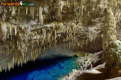
Mato Grosso do Sul region in Brazil (and especially the quiet town of Bonito) boasts many marvelous underground lakes: Gruta do Lago Azul, Gruta do Mimoso, Aquário Natural. The world famous "Gruta do Lago Azul” (Blue Lake Cave) is a natural monument whose interior is formed by stalactites, stalagmites and a huge and wonderful blue lake. The beauty of the lake is something impressive. The Blue Lake Cave has a big variety of geologicalformation but impresses mainly for the deep blue colored water of its inside lake.

Giants Causeway,  Ireland

Click here to enlarge image
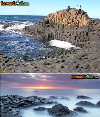
An area of about 40,000 interlocking basalt columns, the Giants Causeway is a result of an ancient volcanic eruption. Located on the north-east coast of Northern Ireland, most of its columns are hexagonal, although there are also some with four, five, seven and eight sides. The tallest are about 12 meters (36 ft) high, and the solidified lava in the cliffs is 28 meters thick in places. In a 2005 poll of Radio Times readers, the causeway was named as the fourth greatest natural wonder in the United Kingdom.

Hell Gate,  Uzbekistan

Click here to enlarge image
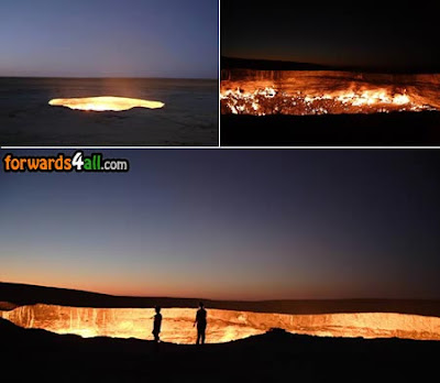
Called by locals The Door to Hell, this place in Uzbekistan is situated near the small town of Darvaz. When geologists were drilling for gas, 35 years ago, they suddenly found an underground cavern that was so big, all the drilling site with all the equipment and camps got deep deep under the ground. None dared to go down there because the cavern was filled with gas, so they ignited it so that no poisonous gas could come out of the hole, and since then, it has been burning. Nobody knows how many tons of excellent gas has been burned for all those years but it just seems to be infinite.

Wave Rock,  Austiralia

Click here to enlarge image
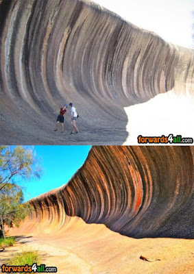
The Wave Rock is a natural rock formation located in western Austiralia. It derives its name from the fact that it is shaped like a tall breaking ocean wave. The total outcrop covers several hectares; the "wave" part  about 15 meters high and approximately 110 meters long. One aspect of Wave Rock rarely shown on photographs is the retaining wall about halfway up. This follows the contours and allows rainwater to be collected in a dam. It was constructed in 1951 by the Public Works Department, and such walls are common on many similar rocks in the wheatbelt.

Chocolate Hills,  Philippines

Click here to enlarge image
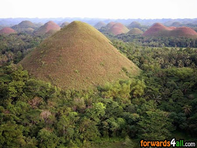
Composed of around 1,268 perfectly cone-shaped hills of about the same size spread over an area of more than 50 square kilometres (20 sq mi), this highly unusual geologicalformation, called Chocolate Hills, is located in Bohol, Philippines. There are a number of hypotheses regarding the formation of the hills. These include simple limestone weathering, sub-oceanic volcanism, the uplift of the seafloor and a more recent theory which maintains that as an ancient active volcano self-destructed, it spewed huge blocks of stone which were then covered with limestone and later thrust forth from the ocean bed.